


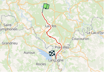
J2 Stevenson: Le Bouchet - Langogne

ARPF
User

Length
28 km

Max alt
1239 m

Uphill gradient
389 m
Km-Effort
34 km

Min alt
899 m

Downhill gradient
695 m
Boucle
No
Creation date :
2015-05-28 00:00:00.0
Updated on :
2015-05-28 00:00:00.0
7h09
Difficulty : Medium

FREE GPS app for hiking
 SityTrail
IGN / Geographical institutes
SityTrail Plus
The world is yours!
About
Trail Walking of 28 km to be discovered at Auvergne-Rhône-Alpes, Haute-Loire, Le Bouchet-Saint-Nicolas. This trail is proposed by ARPF.
Description
IE 88, P2 T1
Positioning
Country:
France
Region :
Auvergne-Rhône-Alpes
Department/Province :
Haute-Loire
Municipality :
Le Bouchet-Saint-Nicolas
Location:
Unknown
Start:(Dec)
Start:(UTM)
562406 ; 4970883 (31T) N.
Comments